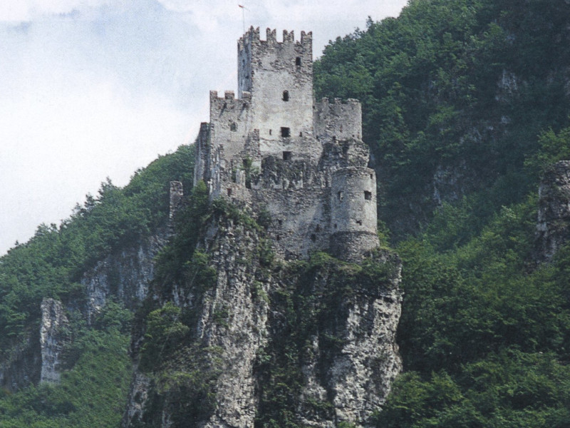
Salorno
Salorno (German: Salurn) is the southernmost comune (municipality) in South Tyrol in northern Italy, located about 30 kilometres (19 mi) southwest of the city of Bolzano. It is one of only five mainly Italian speaking municipalities in South Tyrol. Geography As of 31 December 2011, it had a population of 3,591 and an area of 33.2 square kilometres (12.8 sq mi). Salorno is located in the Adige (Etsch) valley, about 20 kilometres (12 mi) northeast of the city of Trento and about 30 kilometres (19 mi) southwest of Bolzano. Parts of the area belong to the Naturpark Trudner Horn nature reserve, which is part of the Natura 2000 network. Salorno borders the following municipalities: Kurtinig, Margreid, Montan and Neumarkt in South Tyrol, as well as Capriana, Cembra, Faver, Giovo, Grauno, Grumes, Mezzocorona, Roverè della Luna and Valda in Trentino. Frazioni The municipality contains the frazioni (subdivisions, mainly villages and hamlets) Gfrill (Italian: Cauria) and Buchholz (Pochi). History ″Salurn un gros bourg aux confins d'Allemagne e d'Italie dans le Tirol, dont il fait la séparation.″(Diderot: Encyclopédie, 40, 548.) Origin A settlement since the days of the Roman Empire, Salorno in the Kingdom of the Lombards was first mentioned in a 580 deed as Salurnis during the Rule of the Dukes, when Duke Euin of Trent fought against the Frankish troops of the invading Merovingian kings Guntram and Childebert II. The village is best known for the ruins of the medieval castle Haderburg (Italian: Castello di Salorno). Situated on a limestone rock high above the Adige Valley, it marked the linguistic border between the German and the Italian speaking population of the Austria-Hungary Kronland Tyrol. The Salurner Klause, the bottleneck in the gorge below, was also characterized in the Bozner Bergsteigerlied as the southern end of South Tyrol. The castle was first mentioned in a 1053 travelogue and became the property of Count Meinhard II of Tyrol in 1284 and bequested to the House of Habsburg in 1363. Since 1648 the ruins are in possession of the counts Zenobio-Albrizzi. Salorno was annexed to Italy together with the rest of South Tyrol and other areas of the Austrian territory, as consequence of the Treaty of Saint-Germain-en-Laye on 10 October 1920. According to the census of 1921 the majority of the population of Salorno declared themselves as German speaking. After that a governmental commission adjusted the result by modifying the declaration of people whose family name sounded Italian. Salorno and other municipalities of South Tyrol have since then an Italian speaking majority. The effective Italianization conducted by the fascist Regime changed definitively the proportion between the languages. Only 37% of the inhabitants speak mainly German today. Coat-of-arms The emblem is argent a pile reversed and chief azure. It is the insignia of the Lords of Graland who obtained the village in the thirteenth century. The emblem was adopted in 1971. Society Linguistic distribution According to the 2011 census, 61.85% of the population speak Italian, 37.74% German and 0.40% Ladin as first language. Demographic evolution References Further reading Stolz, Otto (1946). "Neumarkt und Salurn in ihren Beziehungen zur Tiroler Landesgeschichte". Der Schlern 20: 292–99. Obermair, Hannes (2001). online "Soziale Produktion von Recht? Das Weistum des Gerichts Salurn in Südtirol von 1403". Concilium medii aevi 4: 179–208. ISSN 1437-904X. Landi, Walter (2010). Haderburg. Die Feste an der Salurner Klause (Burgen, 5). Regensburg: Schnell & Steiner. ISBN 978-3-7954-2163-2. External links Media related to Salorno at Wikimedia Commons (Italian) (German) Homepage of the municipality

