Nocera Umbra
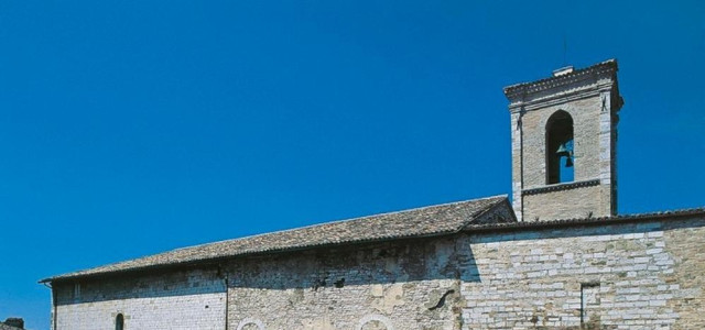
Nocera Umbra is a town and comune in the province of Perugia, Italy, 15 kilometers north of Foligno, at an altitude of 520 m above sea-level. The comune, covering an area of 157.19 km², is one of the largest in Umbria. History The town of Nocera was founded in the 7th century BC by inhabitants from Camerinum, an Umbrian town, who left their ancestral homeland during a so-called ver sacrum (sacred spring). The name Nocera in the Osco-Umbrian language was Noukria, meaning "New" (town). The Roman town was not located on the hill - where modern Nocera lies - but in the valley, near the Topino creek. The town - with the Latin name Nuceria Camellana – came under Roman control between the end of the 4th century and the first decades of the 3rd century BC, and became a Municipium. It soon acquired strategic importance because it lay on a branch of the via Flaminia, the road which linked Rome to the Adriatic, going from Forum Flamini (S. Giovanni Profiamma, near Foligno) to Fanum, on the Picenum. Several remains of the Roman roads are still visible today. From Nuceria the Romans also built another road – the Septempedana - leading to the Roman military outposts of Prolaqueum and Septempeda, on the Adriatic side of the Apennines. According to Pliny the Elder, Nuceria was inhabited by two tribes, one the Nucerini Favonienses (faithful of Favonia, also named Fauna, a Goddess) and the other Camellani (originating from Camerinum, or possibly makers of camellae, small wooden containers). Strabo records that the town was famous for the production of wooden vases (possibly barrels). During the second Punic war, in 217 BC, Hannibal, on his way to the Adriatic after the battle of Trasimeno, is said to have camped with his army near the town (in a place still known as Affrica). Near Nuceria, on the shores of what is now the dried up Lacus Plestinus, the commander of the Roman cavalry, Gaius Centenius, fought a battle with 4,000 knights against Carthaginian troops headed by Maharbal. The town reached the height of its prosperity during the first two centuries AD. During the 5th century, the diocese of Nocera was formed. The Roman town was destroyed at the beginning of 5th century, possibly by the Visigoths: the survivors rebuilt their homes on top of the hill, where today's Nocera still stands. The Lombards occupied the town and stationed an Arimannia there, then a Gastaldatus and finally, at the beginning of the 9th century (during the Frankish period) it became a county. The walled town – it was named arx fortissima in contemporary documents - guarded the northern border of the Duchy of Spoleto against the Byzantine garrison at Gualdo Tadino. The importance of Nocera during the Lombard period is underlined by the Necropolis excavated in 1897, whose artefacts – weapons, jewels, household utensils, ceramics - form the core of the Museo dell'alto Medioevo in Rome. During the Middle Ages Nocera became a walled town, very much as it exists today. In 1202 the town came under the control of Perugia, and in 1248 it was destroyed by emperor Frederick II. Shortly thereafter it came into the possession of the Trinci of Foligno. In 1421 the Castellan of Nocera, Pietro di Rasiglia, suspecting his wife of adultery with Niccolò I Trinci, invited the whole Trinci family to a hunting party and had them all killed, except the young Corrado, who took revenge for the murder of his relatives, attacking the town and killing the treacherous castellan. In 1439 Cardinal Giovanni Vitelleschi crushed the Trinci's Signoria, and Nocera was annexed to the Papal States. The town, with the exception of the Napoleonic period, remained under papal control until 1860 when, as a part of Umbria, it was annexed to the Kingdom of Italy. The town and the surrounding hamlets have been struck several times by earthquakes. The major ones took place on April 30, 1279, April 17, 1747, and September 26, 1997. The damage caused by the last of these has not yet (2014) been fully repaired. Main sights It has some old churches, containing pictures and frescoes; in the Cathedral is a large altarpiece by Niccolò Alunno. Six kilometers south-east of the town (frazione of Bagni) is the Angelica mineral spring. The principal mountain is the Monte Pennino with an altitude of 1,575 m. Frazioni Acciano, Africa, Aggi, Bagnara, Bagni, Boschetto, Boschetto Basso, Capannacce, Casaluna, Casa Paoletti, Case, Case Basse, Castiglioni, Castrucciano, Cellerano, Colle, Collebrusco, Colle Croce, Colpertana, Colsaino, Gaifana, Isola, La Costa, Lanciano, Largnano, Le Moline, Maccantone, Mascionchie, Molina, Molinaccio, Montecchio, Mosciano, Mugnano, Nocera Scalo, Nocera Umbra Stazione, Pettinara, Ponte Parrano, Salmaregia, Schiagni, Sorifa, Stravignano, Villa di Postignano, Ville Santa Lucia. Twin towns Frosinone, Italy Sources Sigismondi, Gino (1979). Nuceria in Umbria (in Italian). Ediclio, Foligno. Boschi, Enzo, and others (1988). I terremoti dell’Appennino umbro-marchigiano area sud orientale dal 99 a.C. al 1984 (in Italian). ING-SGA, Bologna. References This article incorporates text from a publication now in the public domain: Chisholm, Hugh, ed. (1911). Encyclopædia Britannica (11th ed.). Cambridge University Press.